
How Cabell County Property Records Fit Together
No single database holds all of the Cabell County property records. The Assessor's GIS viewer and PDF tax maps turn a street address into a district, map, and parcel key. A sub-parcel key rounds it out. That key then drives the Sheriff's tax search. It also offers a strong clue when you dig through the County Clerk's recorded-document index. Ownership questions start with the latest deed. Tax ticket questions go to the Sheriff. Location questions belong in the GIS Experience.
An address is a fine starting point. But older deeds may identify a property by district, lot, or map book. Some use a former street description. Cabell's parcel, tax, and deed systems are separate, so compare identifiers across all three. A search result shows what an office recorded or assessed. It is not a title opinion or a survey. It is not proof that an online display captures every historical instrument.
- Locate the property in the Assessor’s GIS or tax-map series and write down the full district-map-parcel-sub-parcel key.
- Use the owner name or legal description to search the County Clerk’s IDX, separating grantor and grantee roles.
- Check the Sheriff’s Tax Office for ticket year and paid or unpaid status, and check the Assessor for value and classification.
- Compare the parcel shape and local map folder with the recorded deed or plat when boundary context matters.
- Ask the custodian for a copy or inspection route if the item is not available online; do not assume an online index is complete.
Cabell County Property Records Offices and Their Roles
The County Clerk serves as custodian of recorded documents, while the Assessor and the Sheriff handle separate tax-side questions. Match your question to the office that created the record instead of treating any one portal as a stand-in for the others. The courthouse sits in Huntington, the county seat.
Cabell County Clerk
750 5th Avenue, Suite 108
Huntington, WV 25701
304-526-8625
Cabell County Assessor
GIS, tax maps, forms, homestead information, and tax estimator
County assessment and parcel resources
See the official office contact page
Cabell County Sheriff’s Tax Office
Tax tickets, taxpayer accounts, and payment status
PO Box 2114, Huntington, WV 25721
304-526-8672
Cabell County Property Records in the Clerk’s IDX
The County Clerk's search is an index to a wide range of recorded material. It is not a simple deed lookup. Its visible groups cover Deeds, Liens, Estates, UCC, Miscellaneous, Birth, Marriage, and Death. Property researchers can filter by name role, document type, book, index, and date range. They can then choose among Index Search, Image Search, and Vault Indexes Search. The date control accepts entries from January 1, 1900. It runs through the current date shown in the interface. That is a boundary of the software. It is not a promise that an image exists for every year.
| IDX control | Cabell search use | What to check |
|---|---|---|
| Name role | Grantor, grantee, creditor, or debtor | Search both directions when tracing a transfer. |
| Type and book | Deed, lien, release, map, trust deed, or estate record | Choose the instrument family that fits the question. |
| Date range | Narrow a known transfer period | Use the date printed on the instrument as a cross-check. |
| Result fields | Index flag, status, date, instrument, book/page, pages, names, cross-date, type | Confirm image access and the legal description separately. |
Other labels worth knowing include deed with map, corrective deed, death deed, easement, boundary line, declaration of trust, certificate of transfer, mechanics lien, lis pendens, report of trustee's sale, record of delinquent land, and map book. Surveyors record rounds out the list. A release may sit under a label different from the original mortgage or lien. So may an assignment. The landing page states no image fees. It also guarantees no online image access. Confirm charges with the Clerk before you rely on a download.
The Assessor's site introduces the related maps. It also introduces the value tools you will want before a deed search. Cabell County deed records explains the index more fully.
Cabell County Property Records Separate Value from Tax Bills
The Assessor estimates taxable property. It tracks classification and exemption information. It also links out to mapping tools. The Sheriff's Tax Office provides the account and ticket view. Its search controls cover taxpayer first and last name, account number, tax year, ticket number and suffix, district, map, parcel, and sub-parcel. Real or personal property, tax-year limit, and paid or unpaid status are also options. When a name or street search turns up nothing solid, use the full map key. The office can give you a definitive bill or status.
The Assessor's 2026 FAQ lists different rates by place and class. Class 2 means owner occupied; Classes 3 and 4 are non-owner occupied. The tax estimator takes assessed value, year, district, class, and homestead status. It clearly returns just an estimate. A ticket amount, an assessed value, and a deed consideration answer three different questions. The property tax records guide follows the payment, exemption, and assessment route.
The Cabell County Assessor's home page gathers its GIS, tax maps, forms, homestead material, FAQ, and estimator links. They all sit in one place.

This screenshot shows the Assessor's resource doorway rather than a parcel result card. Follow the GIS or tax-map link to identify the parcel before comparing value and tax sources.
Cabell County Parcel Records Move to a New GIS Experience
The Assessor’s site now points to an ArcGIS Experience as its main map. The older Web AppBuilder map says it stopped receiving updates in June 2026. It directs visitors to the newer Experience. This is a real migration. A bookmarked legacy map might still explain an old screen. But any current parcel check should start at the Assessor’s live link. Confirm what you see there against the tax map or the recorded instrument before relying on it.
The map offers layers that matter for a Cabell County property search: parcel polygons, tax map and district labels, aerial imagery, roads and addresses. It also covers municipal boundaries, zoning, and floodplain context. The layer panel controls which of these are switched on, so check it inside the map itself. An identify click on a parcel can pull up attributes or a parcel number. Still, a drawn outline is only a reference boundary. When a property line matters on the ground, use a recorded plat or a licensed survey.
The Assessor’s directory also holds annual Cabell map folders running from 2015 through 2026. Locality folders sit there too. These PDF tax maps are handy for orientation and for older parcel vocabulary. One caution applies. A new folder date does not mean every parcel in it was reappraised that year. So treat the folders as map history rather than appraisal history.
Open the Cabell tax-map directory to browse the annual and locality map folders. Use it alongside the current GIS map.
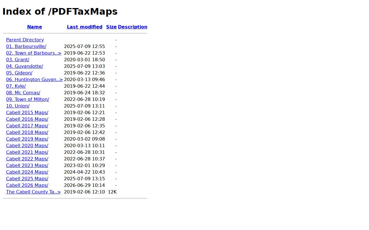
The folder view separates the county's annual map series from its named locality series. It is a map index only.
Cabell County Property Records Reach into Deed Books
West Virginia Archives and History lists Cabell deed books spanning 1809 through 1901, land books from 1809 through 1900, and a deed index covering 1808 through 1968. The same finding aid covers trust deeds, estate records, wills, bonds, contracts, leases, and map or surveyor material. The modern IDX's date control starts in 1900. Older searches may need Archives or courthouse holdings.
Gaps exist inside the index itself. The finding aid flags missing grantor segments Sm-Sz, T-U-V, and W-X-Y-Z, plus a Grantee D segment, within the 1808-1922 index material. A missing entry does not prove no transfer occurred. Try spelling and name variants. Inspect adjacent letter groups too. Once the likely year or parties are known, look in the original deed book. Note which index and deed book you checked, since this gap is a real Cabell research issue.
The Local History Room at Cabell County Public Library adds newspapers, microfilm, photographs, directories, and address context. Those sources can explain a street or household history. The recorded deed still settles the transfer. Cabell shows no courthouse fire or flood loss. So a search gap should not be blamed on a disaster without evidence.
West Virginia Archives' Cabell finding aid describes the historic book and index runs in detail.
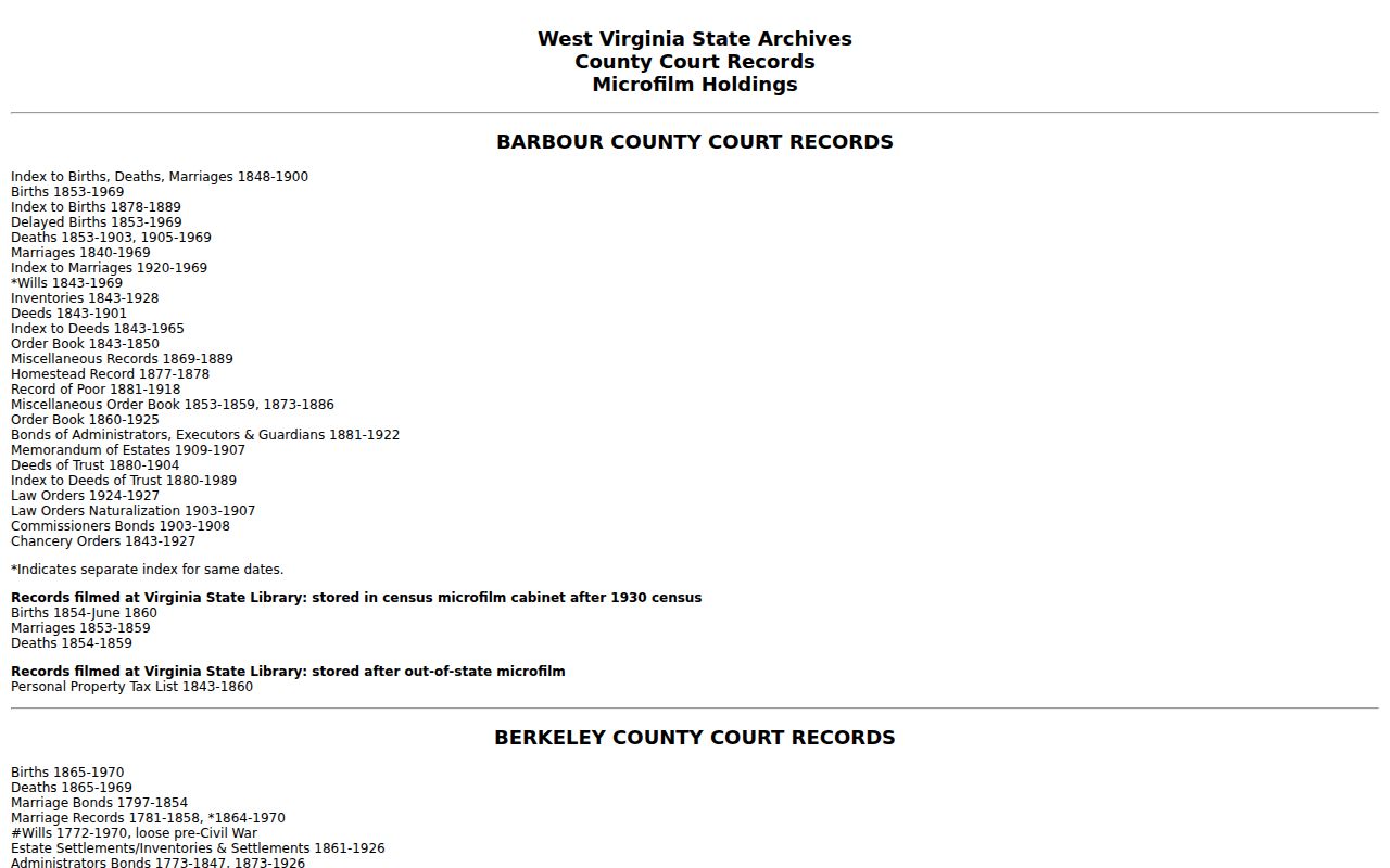
The finding aid guides you to records held on microfilm or in books, not to digitized deed search results. Record the exact series and years.
Cabell County Property Records Use Older District Names
Cabell map directories carry a mix of names: Guyandotte, Huntington Guyandotte, Grant, Gideon, Kyle, McComas, Union, Barboursville, Town of Barboursville, and Town of Milton. Old deeds, census pages, and directories often use them. A current mailing address may simply say Huntington, Barboursville, or Milton. Treat the older name as a clue. Then match the legal description and tax-map key to the current parcel.
Huntington is the county seat, yet the city spills into Wayne County. A Huntington address alone proves little. Verify the county line and tax district. Barboursville's 25504 and Milton's 25541 ZIPs do not define incorporated boundaries either. Municipal checks matter for permits and zoning. Cabell remains the deed custodian for Cabell parcels.
By 2020 counts, Huntington, Barboursville, and Milton stand as the county's three largest incorporated places. Each offers its own map-series clues. Huntington includes Guyandotte labels, Barboursville keeps two separately named folders, and Milton has a Town of Milton folder. Each city page follows its own local route.
Cabell County Property Records Do Not Include City Permits
Recorded deeds and tax parcels answer county record questions; municipal permits and zoning live elsewhere. Huntington's Tyler Public Information Search exposes permit type, permit number, and service address. The city's permit page covers construction, enlargement, alteration, repair, moving, demolition, occupancy changes, and regulated electrical, gas, mechanical, or plumbing work. It lists a $20 application fee. The total fee is based on labor and materials.
Planning and Zoning handles zoning-map and city-boundary lookups, floodplain management, development review, and historic preservation. A historic property may need a Certificate of Appropriateness. That review precedes exterior work, demolition, relocation, or signage. Resolve the parcel in County GIS first. Then check the city boundary and permit record. No comparable portal is listed for Barboursville or Milton, so ask those offices directly rather than using Huntington's system.
Cabell County Property Records Keep Assessment Separate from Sale Price
West Virginia law sets most assessments at 60 percent of true and actual value. That number is statutory, not a market opinion. It will rarely match what a buyer actually pays for a house or lot. A deed may state consideration or cite a transfer, but the assessor card does not display an exact sale-price field. Treat the two as separate documents. Compare a recorded deed with the assessment and current parcel details instead of reading a tax estimate as an appraisal.
Local class rates drive the tax bill. For 2026, the Assessor FAQ reports Huntington at 1.67520 for Class 2 and 3.35040 for Class 4. Rural Cabell sits at 1.35520 for Class 2 and 2.71040 for Class 3. Barboursville lists 1.73020 and 3.46040, while Milton lists 1.60000 and 3.20000. No single county rate exists. Before comparing bills, check the parcel's district, class, and homestead status.
The Assessor FAQ publishes current class, rate, and filing information.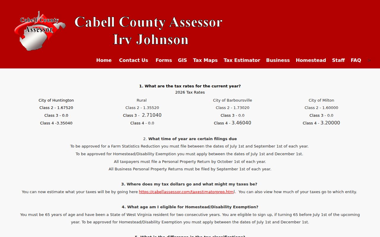
Rates and calendars shift. Run a fresh lookup in the current FAQ and confirm any bill with the Sheriff's Tax Office.
Cabell County Property Records Not Online Can Be Requested
A plat, older book, assessor detail, or an index may be missing from the county's online offerings. Go to the office that keeps it. West Virginia's Freedom of Information Act also offers a route. A request simply needs to name the record or series. Include enough detail to locate the record. Cite the parcel key, instrument number, parties, date range, or book and page. The law then puts duties on the custodian. A response must come as soon as practicable. The limit is five days, not counting Saturdays, Sundays, and legal holidays. The office can provide copies or set an inspection time. It can also deny the request in writing with its reasons.
Fees are limited to actual reproduction costs. The statute does not allow a charge for search or retrieval labor. FOIA also has limits of its own. It cannot open sealed court records. It cannot shorten vital-record waiting periods or release protected data subject to other legal restrictions. Keep your request and the response on file. Ask whether inspection, mail, or a digital copy is available. For deed images and certified copies, confirm the current method and charge with the County Clerk. The online landing page does not publish those details.
Types of Cabell County Property Records
No single Cabell record answers every property question. Each type covers one piece. A deed records a transfer. An assessor value supports tax administration. A tax ticket tracks payment, and GIS places the parcel for reference. Choose the right source before you search Cabell County property records.
| Record Type | What It Documents | Kept By | Access |
|---|---|---|---|
| Deeds and releases | Recorded transfers and later instruments affecting interests | Cabell County Clerk | IDX search; ask Clerk about image or certified-copy access |
| Mortgages, liens, lis pendens | Recorded claims, notices, assignments, and releases | Cabell County Clerk and court dockets | Search index and confirm any later satisfaction |
| Tax and assessment | Class, exemption, assessed value, account and ticket status | Assessor and Sheriff Tax Office | Separate public portals and office confirmation |
| Maps, plats, parcels | Reference parcel geometry, map key, lot and subdivision context | Assessor GIS/maps and Clerk books | Current GIS, PDFs, recorded map or survey |
| Permits and zoning | City work history and land-use review | Municipal office | Huntington Tyler and Planning; ask other towns directly |
Start with the subject of your question. A new owner or a prior transfer points to a deed. A balance due points to the Sheriff. Value, class, or exemption points to the Assessor. Lot shape or road context points to GIS and the recorded plat. Sometimes a recorded instrument travels with companions. Court, probate, or tax-sale records may matter. Title may have changed through an estate or distress process. Treat the table as a routing guide, not proof that every record is online.
What Cabell County Property Records Can and Cannot Establish
Public records answer many questions. They can show the name on a deed. They can also show the tax account tied to a parcel, assessed value, recorded liens, map references, or a city permit. But they cannot do everything. They do not prove who occupies a property. They do not guarantee that a lien remains open, settle a boundary, or provide a market appraisal. Status can change after filing. A complaint or notice may later be withdrawn, released, satisfied, or superseded. Read the whole chain and the current status. Do not rely on one line in a search result.
Lawful use. Use Cabell County records for property research, due diligence, history, and civic transparency. A search is not title insurance or a boundary survey, and owner information must not be used to stalk, threaten, or harass anyone.