
Finding Nearby Cabell County Parcels and Their Records
A neighbor lookup in Cabell County is really a mapping exercise. Locate the subject property. Note the parcel keys that surround it. Then look up each key separately. The Assessor's current ArcGIS Experience is the map entry point, the Sheriff portal opens each tax account, and the County Clerk records deeds and plats. Treat the visible parcel geometry as a clue. The live map decides which selection tools exist, so work with what it presents and verify against the record source.
| Source | What It Shows About a Block | Access |
|---|---|---|
| Current Assessor GIS | Parcel polygons and nearby map context; attributes must be checked in the active Experience. | Public ArcGIS Experience |
| Sheriff tax portal | Taxpayer/account and ticket search by district, map, parcel, and sub-parcel. | Separate lookup for each key |
| County Clerk map books | Recorded plat, lot labels, deed-with-map, and surveyor references. | IDX and custodian request |
| Library / Archives | Historical street and district context for older block descriptions. | Research collections, not title proof |
These sources will not name everyone on a block. An owner or taxpayer name reflects a public-record role, and the mailing address on the tax bill may sit somewhere else entirely. For each adjacent parcel, separate what the GIS map shows from what the deed or tax account records. That distinction keeps a neighbor search honest.
Mapping a Cabell County Block from One Parcel Key
Open the Cabell GIS and search the subject address. If selection works, grab the local identifier, with its district, map, parcel, and sub-parcel parts, for the subject and every nearby polygon that matters. Use each part in the Sheriff tax search. Compare the owner or taxpayer clue with a County Clerk deed when recorded ownership is the question. A map neighbor is not always a legal neighbor. Roads, rights-of-way, and water features often sit between two shapes that look adjacent. Confirm with the deed before calling a polygon adjoining.
- Open the Assessor’s current ArcGIS Experience, not the legacy map marked no longer updated as of June 2026.
- Locate the subject address and use the visible parcel selection or identify tool if available.
- Write down nearby district-map-parcel-sub-parcel keys; do not assume an unverified GIS layer returns a full owner list.
- Search the Sheriff ticket separately for each parcel key and confirm ownership with the matching Clerk instrument.
- Tax-map key
- District, map, parcel, and sub-parcel fields used to match a Cabell tax account.
- Adjacent parcel
- A nearby mapped parcel; confirm whether it actually shares a legal boundary.
- Plat
- A recorded lot map that provides subdivision context and references.
Privacy Limits on a Cabell County Neighbor Lookup
Public access in West Virginia has limits. Voter files exclude telephone and email details, Social Security numbers, and driver or state ID numbers, while the Address Confidentiality Program can shield qualifying participants. Keep a Cabell County parcel search aimed at land, boundaries, ownership evidence, and civic research. A taxpayer name does not show occupancy. Never use a map to target a person.
Lawful use. Use Cabell parcel and deed information for property diligence, boundary context, and local history. Never use a neighbor lookup to watch, intimidate, or harass any person.
Cabell County Neighbors Are Mapped in the Current GIS
The Assessor’s current ArcGIS Experience is the supported parcel map destination. The former Web AppBuilder viewer states it is no longer updated as of June 2026. The research did not text-capture the new interface’s layer names or adjacent-selection controls, so inspect the live map and use only the tools it presents. A parcel polygon can show which tract is next to another on the tax map, but it does not certify a surveyed line.
Where the GIS does not expose a usable owner attribute, take the neighboring parcel key to the Sheriff Tax Office. The key is split into district, map, parcel, and sub-parcel fields. The result inventory was not captured, so call 304-526-8672 for confirmation about a ticket or tax status.
Cabell County Plat Neighbors Can Differ from Map Neighbors
A subdivision plat records the layout. It labels lots, streets, and sometimes rights-of-way. The Assessor PDF maps and GIS serve as tax references. For the recorded plat itself, the County Clerk's Map Book, Deed with Map, and Surveyors Record Book are stronger paths. Match the lot and block to the current parcel key before calling a nearby polygon an adjoining lot, because plat neighbors and map neighbors can differ.
Cabell's map directory spans 2015 through 2026. Annual folders sit beside locality folders. Historic names like Guyandotte and Huntington Guyandotte appear in the map vocabulary even when modern addresses say Huntington. For house history, the library or Archives can explain older street names. The plat and deed still carry the land description. Cabell County's Assessor tax-map directory organizes the annual and locality map series that help you find the right reference.
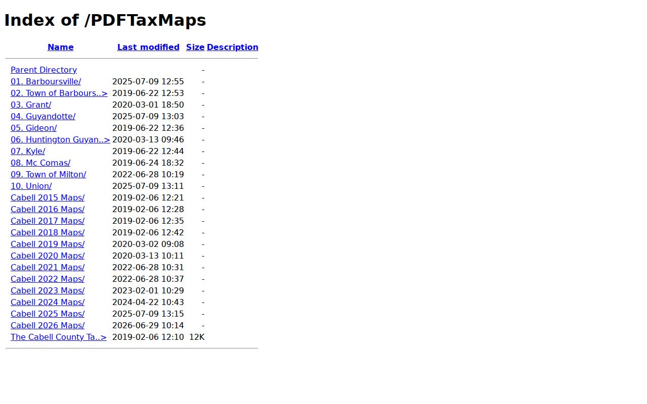
The directory names map series and places. The individual map still must be checked for the parcel depiction, and no tax map is a boundary survey.
Cabell County Neighbor Searches Need Boundary Checks
Nearby parcels can cross district lines. Some even fall in another municipality. Huntington reaches into Wayne County, and Barboursville or Milton mailing addresses may extend past the incorporated places. Check the county GIS and the municipal boundary source before asking a city about permits, since two addresses can share a postal label yet follow different record routes. Barboursville and Town of Barboursville are separate Assessor map-directory labels, and Town of Milton has a locality map series. Treat those names as search clues. They never prove an owner sits inside a boundary. Check each parcel independently.
Cabell County Neighbor Records Show Owners, Not Occupants
A tax mailing address in Cabell County often sits far from the parcel itself. It may point to another town, a trust, or a company. That is normal for an absentee owner of record. It tells you nothing about who actually lives at the property. Treat the tax record as a window into the parcel and its tax account. Consider it nothing more than that.
Match the record to the question you are asking. The deed identifies the legal grantee. The tax ticket shows whether the account is current. A GIS map is good at placing neighboring parcels next to yours. No single property records source answers all of these at once. For a formal property matter, contact the custodian of the records. Avoid pursuing an individual through repeated or intrusive outreach.
Cabell County Neighbor Lookup Is Not a Survey or Title Search
The GIS map is a starting point, not a verdict. At display scale it can generalize, shift, or drop a feature entirely. It still helps you flag which tax maps and property records to pull. But only a licensed surveyor establishes boundary lines.
For recorded ownership and encumbrances, a Cabell County Clerk deed search is the right tool. A parcel-based neighbor lookup is not a title search. It should never serve as a shortcut. Never use it to guess a person's presence, conduct, or household from land records.