
Reading a Cabell County Parcel Map
The Cabell County Assessor posts two mapping tools. One is a current ArcGIS Experience. The other is a directory of PDF tax maps. The GIS works well for spotting a parcel and seeing how it sits against roads and nearby tracts. The tax-map key then connects that parcel to the Sheriff's tax search. Layer panels in the Experience vary, so check which tools are visible before assuming every layer is active.
| Layer | What It Shows | Use |
|---|---|---|
| Parcel polygons | Mapped parcel shapes and identifying attributes, if enabled in the current Experience. | Locate and compare nearby tax parcels; reference only. |
| Tax-map key | District, map, parcel, and sub-parcel vocabulary used by the Sheriff portal. | Match a map location with a tax ticket. |
| Annual PDF maps | Cabell year folders visible from 2015 through 2026. | Check map-series context and historical labels. |
| Locality folders | Barboursville, Town of Barboursville, Guyandotte, Huntington Guyandotte, Town of Milton, and other districts. | Translate older place names into a current parcel search. |
| Other ArcGIS layers | Roads, imagery, municipal lines, zoning, or floodplain may be available; verify in the map. | Context only; confirm with the responsible office. |
Once the parcel is identified, write down its tax-map key. Compare it against the Sheriff account. For ownership, follow the County Clerk deed. That deed contains the legal description. GIS layers, tax maps, and deeds are related references, not interchangeable records.
Finding a Cabell County Parcel from an Address
Use the current ArcGIS Experience linked by the Assessor rather than an old saved bookmark. Search or navigate to the address first. If the select tool is enabled, click the parcel feature and record its key. Then compare that key with an annual PDF map or a tax ticket. Field panels in the interactive map can differ from session to session, so confirm the button labels on screen rather than relying on a fixed description.
- Open the Cabell Assessor site and follow its link to the current ArcGIS Experience.
- Search the street location or navigate the map, then select the parcel feature if identify tools are enabled.
- Record the district, map, parcel, and sub-parcel shown in the related tax material; do not infer an unverified number format.
- Compare the location with the relevant PDF tax-map folder, then use the Sheriff ticket and County Clerk instrument for record confirmation.
- Tax-map key
- Cabell’s district, map, parcel, and sub-parcel fields used to connect a place with a tax account.
- Plat
- A recorded map of lots or a subdivision, searched through the Clerk’s map-related books.
- Lot and block
- A platted land description that should be read with its recorded map.
- Metes and bounds
- Written boundary calls that require the full description and survey context.
What Cabell County Parcel Maps Cannot Prove
Cabell GIS and Assessor tax maps are reference tools. They help you locate a parcel. You can also check its map key and pick the right deed or plat to inspect. A map line settles nothing more. It cannot resolve a disputed boundary, and it cannot establish title. The current Experience may be updated on its own schedule, apart from the PDF map folders. An annual folder date does not prove that every parcel geometry or value changed that year.
Not a survey. Use a licensed surveyor to establish a property line for construction or a dispute. Confirm ownership through the recorded deed, not the Cabell GIS outline.
Cabell County GIS Has a Current and a Legacy Viewer
The Assessor's GIS migration page links the new ArcGIS Experience. The older Web AppBuilder map states that it stopped receiving updates in June 2026. That distinction matters when two saved screens disagree. Follow the current Assessor link for current parcel display. Keep a legacy screenshot only as dated context. Note: the GIS vendor support number on the old page is not the County Clerk or Assessor contact. Layer tools in the Experience can change, so check directly for parcel selection, address search, measurement, print, aerial imagery, district and municipal lines, zoning, or flood tools. When the map cannot answer the question, use the PDF series. Ask the Assessor. Compare the County Clerk record. A map export is still not a certified survey.
Cabell County Parcel Maps Keep Local District Names
The PDF directory separates annual county maps from locality folders. That structure makes it unusually helpful for older descriptions. Visible names include Barboursville, Town of Barboursville, Guyandotte, Huntington Guyandotte, Grant, Gideon, Kyle, McComas, Town of Milton, and Union. Treat one of these names in a deed or directory as a clue. It points to the map series. It is not proof that today's municipal boundary matches. The annual Cabell map folders run from 2015 through 2026. Locality folders can be older or carry their own update dates. Search the city or district label along with the current street address. Then compare the result against today's tax key and legal description. The Assessor tax-map directory lists both the annual and local map folders.
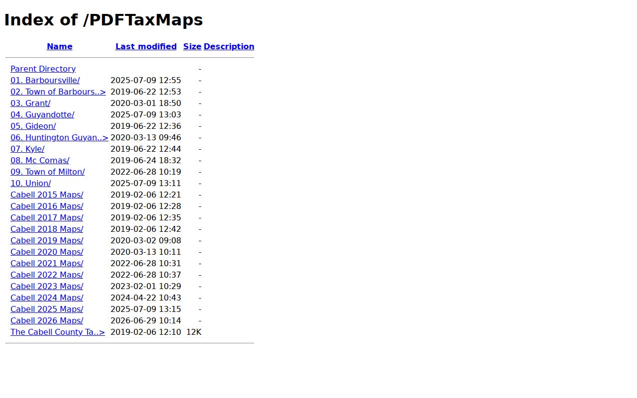
The directory shows map series and place names at a glance. Open the individual PDF to inspect its parcel depiction and date.
Cabell County Plat Books Are Separate from Tax Maps
The County Clerk IDX lists Map Book, Deed with Map, and Surveyors Record Book categories. These are the routes to a recorded plat. They also reach a deed tied to a map, or survey material. An Assessor PDF tax map helps you locate land. But it does not establish a subdivision's legally recorded lot lines. Read the plat name, lot and block, date, and book and page. Then compare those details with the current tax map and the deed description. For historic subdivisions, the Archives finding aid includes map and surveyor material. The public library's local-history room can help with older street names and neighborhood context. Exact Huntington, Barboursville, or Milton plat names and book and page references need confirmation. Use the county map. Use the Clerk result to verify those details. Do this before treating a neighborhood lead as a recorded subdivision.
Cabell County Parcel Maps Help Route City Permit Questions
A deed and a tax account settle ownership. But they never settle which city handles zoning or permits. That job belongs to municipal boundaries. Huntington runs a city-boundary lookup alongside its Planning & Zoning resources. A Huntington mailing address can still sit close to unincorporated county land or even the Wayne County line. Barboursville and Milton raise the same question. Confirm the town limit on the county GIS map first. Then ask that municipal office about the permit. A postal city name or a ZIP code is not a boundary layer. Huntington permit searches run through a separate Tyler service-address tool. Barboursville and Milton publish no public permit portal. Map the parcel. Confirm the incorporated limit. Take the permit question to the municipality that actually governs it.
Cabell County Parcel Maps Can Locate Nearby Parcels
Studying a whole block starts with one parcel. Select it on the current map and note each adjacent tax key the display shows. Then look those keys up individually in the Sheriff and Assessor records. That ties the mapped land to a taxpayer or an assessment entry. The county's GIS layer list offers no particular buffer or adjacent-parcel tool. So plan on manual comparison. Nearby polygons are map neighbors, nothing more. They are not surveyed adjoining owners. For a true subdivision relationship, rely on the recorded plat and its lot labels. GIS may place a road, creek, or right-of-way between parcels that shifts the practical boundary question. The Clerk's map books and the surveyor records remain the stronger source. They show the recorded layout.
Cabell County Parcel Maps Preserve Older Place Vocabulary
Older deeds in Huntington's river and county-seat territory can name Guyandotte or Huntington Guyandotte. The address may read Huntington today. The Assessor directory keeps this history alive too. It separates Barboursville from Town of Barboursville and includes a Town of Milton folder. Search those labels when translating an older deed, census record, or directory entry. Then compare the legal description against the present map. A map folder is a research aid, though, not a ruling on incorporation or annexation. Where boundaries have shifted, municipal boundary sources and the recorded instrument explain the parcel's current context better than the folder name alone.